Short Hikes
Nine of NSW's Best Short Hikes
December 7, 2023 • Corey Grigg
11 min read
New South Wales (NSW) is a treasure trove of natural beauty, and what better way to explore its diverse landscapes than through short walks that pack a punch? From cascading waterfalls to ancient caves and panoramic vistas, these walks offer a taste of the state's rich natural heritage. Lace up your hiking boots, grab your camera, and embark on a journey through the best short walks in NSW.
Not only are these walks a feast for the eyes, but all the walks we have on our list take less than three hours to complete and won’t require you to break much of a sweat. This makes them perfect for that relaxing post-brekkie Sunday stroll or a nice walk while on holiday that we all love.
Crystal Shower Falls Walk
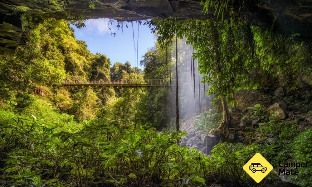
Starting at The Glade Picnic Area, this short walk should be on any waterfall-lovers bucket list. The Crystal Shower Falls Walk takes you through a small section of rainforest to a suspension bridge where you can view the waterfall in all its glory.
Now we don’t want to spoil the whole thing, but the side path connecting to bridge leads to a pretty spectacular view of the waterfall from behind that you have got to see for yourself.
The path is fully paved and you’ll be treated to a huge selection of birdlife, insects and rainforest flora as you stroll along. If you’re not out of puff yet, you can re-join the Wonga Walk, a 6.6km loop further through the rainforest, on your way back.
A map of the tracks can also be grabbed at the Dorrigo Rainforest Centre, where you can also leave a small donation to help with the upkeep of the area.
- Location: Dorrigo National Park
- Grade: 2 - Generally flat with a few gentle hill sections or steps, no experience required
- Distance: 3.5km return
- Suggested time: 1 hour if you’re quick, 2 hours if you plan on sightseeing along the way
- Closest major city or town: Coffs Harbour
- Parking: Available at The Glade Picnic Area
- Where to stay: Belligen Showground
The Big Hole Walking Track
You may be wondering, ‘what’s so great about some big hole in the ground’? Well this isn’t any old ‘hole in the ground’. The aptly named Big Hole is a 400 million year old limestone chasm which is over 50 metres wide and 100 metres deep at its lowest point. Sounds pretty special right?
Well there is a catch to it. On your journey to see The Big Hole, you’ll be faced with one unmovable adversary, the Shoalhaven River. As long as you don’t mind getting your feet wet or bringing a towel, you’ll have no problem tackling it.
A word of warning though, the river bed can be a little slippery, so best bring a pair of grippy hiking boots and possibly a walking pole to help you across. Many bushwalkers are scared off by the water crossing, making this hike all the more special when you reach The Big Hole.
- Location: Deua National Park
- Grade: 4 - A few small steep sections and with a mandatory river crossing chucked in
- Distance: 3.5km return
- Suggested time: 2 to 3 hours
- Closest major city or town: Moruya
- Parking: Available at Berlang campground nearby
- Where to stay: Berlang Campground or Wyanbene Campground
Three Sisters Walk
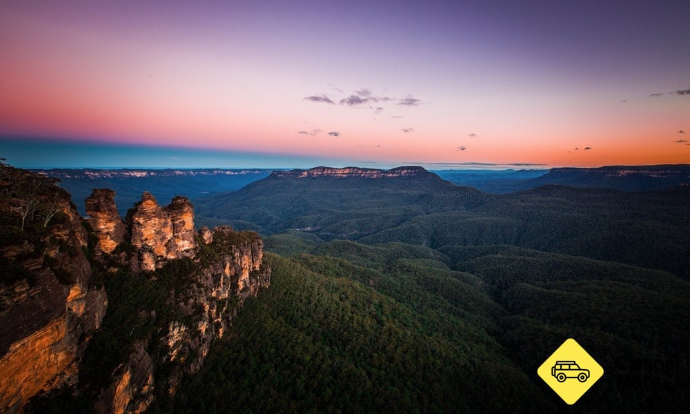
Description: Are you after one of most breathtaking views in the Blue Mountains? Well the Three Sisters Walk is exactly what you’re after. Your buddies back home will be super jealous with the snaps you’ll get from here. We’d say they’re probably even laptop-wallpaper-worthy.
You’ll start the Three Sisters Walk at the Echo Point Visitor Centre, where you can grab a map of the area and learn more about its history. From there, head half a kilometre down the path to the first viewing platform, Oreades Lookout. Here you’ll be able to update your Facebook display picture with an epic view for your backdrop.
If you want an even better view, you can continue up a fairly steep set of stairs to the Lady Game Lookout. If that’s still not enough, you can continue up the Giants Stairways (another steep set of stairs) to Honeymoon Bridge, which connects across to the first of the Three Sisters.
But in recent years, The Three Sisters walk and the township of Echo Point has become increasingly touristy. ‘Peak hour’ for the walk is typically between 9am and 5pm, where you’ll find bus loads of tourists crowding the lookouts.
Our suggestion? Head down there around dusk and dawn for a much quieter experience and to avoid the crowds. If you have to be there during the day and hate crowds, the nearby Leura Cascades Loop (starting from the Leura Cascades Picnic Area), offers similar views without the same hordes of people.
- Location: Echo Point
- Grade: 1 (Majority flat, very small slopes on the track, no experience required)
- Distance: 1km return
- Suggested time: 30 mins return, but you may stay longer to take in the sights
- Closest major city or town: Katoomba
- Parking: Available around Echo Point township, however most parking requires payment during the daytime.
- Where to stay: Katoomba Falls Tourist Park
Princes Rock Walking Track
Just down the road from The Three Sisters, Princes Rock Walking Track has been navigated by sightseers since the 1890s. It provides uncompromised views over the Wentworth Falls and Kings Tablelands.
If you’re into photography, the lookout is the perfect place to practice your panorama skills. Sunrise and sunset also provide some great opportunities to play with the natural light and shadows across the valley.
This walk is a great way to follow up the Three Sisters Walk, as it’s not too strenuous, and gives you a different perspective of the Blue Mountains.
- Location: Blue Mountains National Park
- Grade: 3 - some hilly sections
- Distance: 1.8km return
- Suggested time: 1 hour
- Closest major city or town: Wentworth Falls
- Parking: Available at Wentworth Falls picnic area
- Where to stay: Katoomba Falls Tourist Park
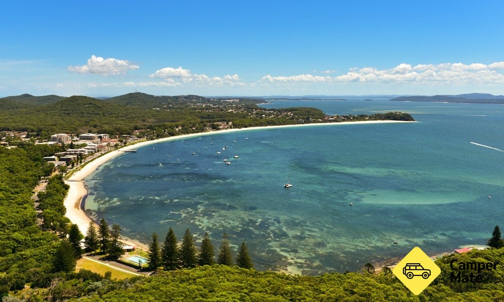
Tomaree Head Summit Walk
Tomaree Head Summit Walk isn’t so much a walk, as it is a climb . You’ll hear the words, ‘invigorating’, ‘bloody tiring’ and ‘spectacular’ thrown around when people talk about this track, and with good reason.
Although it’s only a two kilometre round trip, the whole thing is very steep, with a mixture of stairs, steps and tough sloping path. This track is not for the unfit or faint-hearted.
How are you rewarded for your efforts? Amazing views of the Port Stephens area, Nelson Bay and nearby Boondelbah and Shark Islands. The summit also features picnic tables and chairs so you can enjoy a meal with a unforgettable view before you head back down.
We’d also suggest taking a pair of binoculars with you if want to fully enjoy the sites. If you’re doing the climb in winter, be sure to keep your eyes out for humpback whales migrating along the coastline
If you’re keen on Australia’s military history, you can also take a two-hour detour down the Fort Tomaree Walk (which is far easier than the summit walk), to check out some of Australia’s WWII coastal gun emplacements.
- Location: Shoal Bay
- Grade: 5 - Very steep for the majority of the track, recommended for experienced hikers
- Distance: 2km return
- Suggested time: 2 hours return, but you may stay longer to take in the sights or catch your breath
- Closest major city or town: Nelson Bay
- Parking: Available at either lower or upper Zenith Beach car park
- Where to stay: Shoal Bay Holiday Park
Sandstone Caves Walking Track
The Sandstone Caves is one of the best places to see Aboriginal rock art and engravings in NSW, created by past generations of the local Gamilaroi people. But there is a couple of special rules you’ll need to abide by when you visit the area.
First of all, the track isn’t marked, as requested by Gamilaroi elders, so you’ll need to swing by the Pilliga Discovery Centre to get the directions to the cave. Here you can also book a guided tour to get a deeper understanding of the place. While on the track you’ll find interpretive signs about the caves too
When you reach the caves, you're not allowed to touch the artwork or take flash photography. By playing by the rules, we won’t spoil the rich history here for future generations. It’s also worth calling the discovery centre ahead of time to see what the road conditions are like. If there has been prolonged rainfall, the road to the caves can be very hazardous.
- Location: Pilliga National Park
- Grade: 3 - Some steps and gentle hills
- Distance: 1.7km loop
- Suggested time: 1.5hours
- Closest major city or town: Dubbo
- Parking: Available at Sandstone Caves Walking Track
- Where to stay: Salt Caves Campground
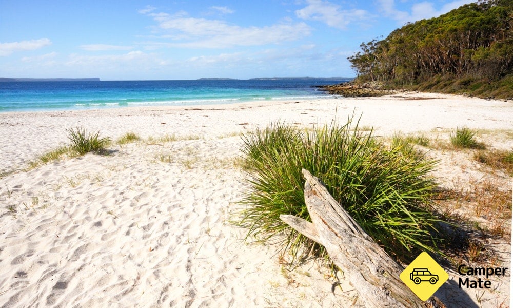
White Sands Walk and Scribbly Gum Track Loop
 )
)
Typically when you do this walk, you start with the White Sands section and end with the Scribbly Gum Track. But, here’s a hot tip for you: do it the other way around, you won’t regret it!
Here’s why. Both tracks run parallel to each other, with the Scribbly Gum side winding through a tall coastal forest and the White Beaches Walk following along the beachfront of Jervis Bay. Both start or end (depending which walk you begin with) at Greenfield Beach Picnic Ground.
Why should you start with Scribbly Gum Track you may be wondering? Well, if you bring your budgie smugglers with you, you’ll be able to take a cool, relaxing swim along the beach before walking back along the sand to the car park. Sound like an afternoon well spent? We think so too.
If you want to stretch the legs a bit more, continue heading south past the Scribbly Gum Track and White Sands Walk intersection over Duck Gully to Chinamans Beach.
- Location: Jervis Bay
- Grade: 3 - A few small sections that can be fairly steep or strenuous
- Distance: 2.5km return
- Suggested time: 30 mins to 2 hours depending on pace, potentially longer if you decide to take a swim or sunbake
- Closest major city or town: Nowra
- Parking: Available on Elizabeth Drive near Greenfield Beach picnic area
- Where to stay: Tasman Holiday Park Myola or Holiday Haven Swan Lake
The Granites Walking Track
Located deep in the New South Wales outback, The Granites are remnants of the 450 million year old volcano in the Sturt National Park. Magma hardened in the cracked earth, creating huge granite boulders. The Granites Walking Track is a place few travellers have explored and would certainly make your mates back home very jealous.
The abundant wildlife is also worth the drive to this far-off land. Bearded dragons, a variety of geckos and stumpy tail lizards are commonly seen sunbaking in the area. You may even see a kangaroo or ten grazing around the park
But, because The Granites are in the outback, it’s best to save this walk for the colder months when the mercury isn’t about to burst.
- Location: Sturt National Park
- Grade: 3 - Some steps and gentle hills
- Distance: 3km loop
- Suggested time: 2 to 3 hours
- Closest major city or town: Tibooburra
- Parking: Available at Dead Horse Gully campground, north of Tibooburra
- Where to stay: Dead Horse Gully Campground
Chandler Walking Track
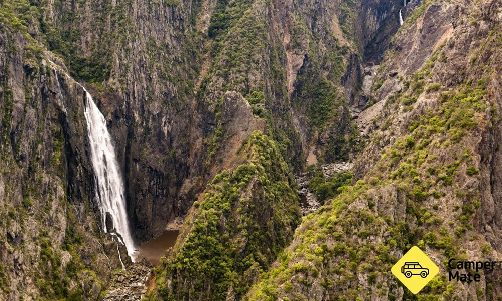
What’s red, thirsty and a little bit sweaty? You on the Chandler Walking Track. We’d be lying if we said this one was easy. Obstacles, big sections of steps, it’s almost like you’re climbing up the side of a mountain – which is pretty much what you’re doing.
Is it worth it? A sweaty yet satisfied two thumbs up from us. From the carpark, you’ll only have to walk a short while down the track to find the main Falls lookout, giving you a glimpse of what is to come. If you carry on you’ll reach the second Checks Lookout, where you’ll see the ravine from a fresh perspective. After catching your breath and a bit of a climb, you’ll be rewarded with the Chandler Lookout, which offers the best view over the gorge.
- Location: Oxley Wild Rivers National Park
- Grade: 5 - Some steep sections
- Distance: 2.5km return
- Suggested time: 2 hours
- Closest major city or town: Armidale
- Parking: Available at Wollomombi Falls picnic ground
- Where to stay: Wollomombi Campground or BIG4 Armidale Highlander Van Village
Well, that’s it, our favourite short hikes across New South Wales. We’re sure they’re many more that we haven’t mentioned. You may even have some secret ones of your own